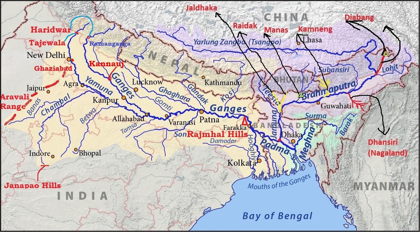
- Source: Chemayungdung glacier (Kailas Range) at an elevation of about 5,150 m. It’s source is very close to the sources of Indus and Satluj.
- Mariam La separates the source of the Brahmaputra from the Manasarovar Lake.
- Brahmaputra flows eastwards in Southern Tibet for about 1,800 km.
- In Tibet it passes through the depression formed by the Indus-Tsangpo Structure Zone between the Great Himalayas in the south and the Kailas Range in the north.
- Inspite of the exceptionally high altitude, the Tsangpo has a gentle slope. The river is sluggish and has a wide navigable channel for about 640 km.
- It receives a large number of tributaries in Tibet. The first major tributary is the Raga Tsangpo meeting the Tsangpo near Lhatse Dzong.
- Towards the end of its journey in Tibet, its course abruptly takes a south ward turn around Namcha Barwa (7,756 m)(Syntaxial Bend).
- Here it cuts across the eastern Himalaya through the Dihang or Siang Gorge and emerges from the mountains near Sadiya in the Assam Valley.
- Here it first flows under the name of Siong and then as the Dihang.
- In the north-eastern parts of Assam Valley, it is joined by two important tributaries viz, the Dibang (or Sikang) from the north and Lohit from the south.
- The main streams merging with the Brahmaputra from the north are, Subansiri, Kameng, Dhansiri (north), Raidak, Tista etc..
- The Tista was a tributary of the Ganga prior to the floods of 1787 after which it diverted its course eastwards to join the Brahmaputra.
- The Brahmaputra has a braided channel (flow into shallow interconnected channels divided by deposited earth) for most of its passage through Assam where channels keep shifting. It carries a lot of silt and there is excessive meandering.
- The river is nearly 16 km wide at Dibrugarh and forms many islands, the most important of which is MAJULI. It is 90 km long and measures 20 km at its widest.
- With rainfall concentrated during the monsoon months only the river has to carry enormous quantities of water and silt which results in disastrous floods. The Brahmaputra is thus truly a River of Sorrow.
- The river is navigable for a distance of 1,384 km upto Dibrugarh from its mouth and serves as an excellent inland water transport route.
- Brahmaputra bends southwards and enters Bangladesh near Dhubri.
- It flows for a distance of 270 km in the name of Jamuna river and joins the Ganga at
- The united stream of the Jamuna and the Ganga flows further in the name of
- About 105 km further downstream, the Padma is joined on the left bank by the Meghna, originating in the mountainous region of Assam.
- From the confluence of Padma and Meghna, the combined river is known as the Meghna which makes a very broad estuary before pouring into the Bay of Bengal.

| Tibet | Tsangpo (meaning ‘The Purifier’) |
| China | Yarlung Zangbo Jiangin |
| Assam Valley | Dihang or Siong, South of Sadiya: Brahmaputra |
| Bangladesh | Jamuna River |
| Padma River: Combined Waters of Ganga and Brahmaputra | |
| Meghana: From the confluence of Padma and Meghna [View image above]1 |
Comments
Post a Comment